Official tourism website for Northern Ireland
En

Gortmore to Hell's Hole

Gortmore Viewpoint, Bishop's Road, County Londonderry, BT49 0LJ
Gortmore to Hell's Hole

Book Tickets Online

About

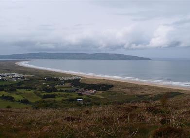
A lovely walk along the cliff top overlooking Benone Beach, Lough Foyle and the Inishowen Peninsula in Co. Donegal

Start Point:
C716342

Finish Point:
C716342

Route:
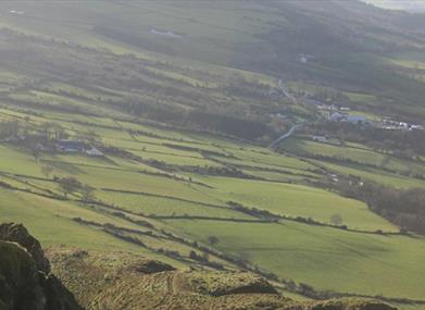
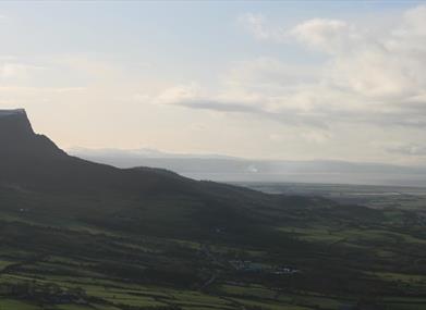
On entering Gortmore view point from the car park spaces turn left immediately and look for a stile to cross the fence near the cliff line IC 715 342. Head south keeping the fence line on your right with the distinct outline of Binevenagh Mountain and the expanse of Lough Foyle in front of you (visibility permitting of course).  You are now walking through the townland of Gortmore. The trail flows gently downhill through this grazed upland area, after approximately 400 metres you meet a small headland IC 714 338. Take the time to look northwards from this point to view one of the largest sand dune systems in the UK  & Ireland that forms part of Magilligan Special Area of Conservation as well as the classic land slips below the cliff line. Continue south wards along the fence line as the alluvial plain of Magilligan spreads out below you to the west. Many of the fields immediately below the cliff feature stone walls and have an undulating topography that contrasts with the larger level fields that stretch down to meet with the Lough Foyle shore. The area around the Duncrun Road is a raised beach and is home to a range of archaeological features. Keep following the fence line to meet an old iron gate which forms part of a ‘slap’, IC 711 330 turn left to follow the fence uphill a short distance and then continue on to sweep round to meet a stile to take you onto the Bishop’s Road IC 713 326. You skirt past Hell’s Hole a distinctive gulley which is best seen from the Duncrun Road or Seacoast Road. Please note that Hell’s Hole is not publicly accessible. Cross the stile and carefully turn left onto the Bishop’s road keeping an eye out for traffic and follow the road north for 1.5 kms as it climbs gently to return to Gortmore Viewpoint. Please note this walk can be combined with the Avish to Eagles Hill route to make a 5 mile long route.

Distance:
2.2 miles

Terrain:
cliff top, open field,quiet road

Point of interest:
Binevenagh, Magilligan Sand Dunes, Hell's Hole

Facilities:
Car Park

Nearest town:
Bellarena

OS map:
4

Book Tickets

Map & Directions

What's Nearby

  1. Gortmore's superb Viewpoint situated on the Bishop's Road on the Binevenagh Loop, as part…

    0 miles away
  2. Benone Strand, multiple recipient of the European Blue Flag and Seaside Award, is a…

    1.33 miles away
  3. Downhill is a golden sandy beach stretching from Downhill Cliffs in the east towards…

    2.53 miles away
  4. Mussenden Temple is located in the beautiful surroundings of Downhill Demesne near…

    2.84 miles away
  5. Hezlett’s picturesque thatched cottage exterior hides a fascinating early timber frame…

    2.84 miles away
  6. Binevenagh is a tranquil area where the sights of Lough Foyle and Donegal can be seen on…

    2.87 miles away
  7. An inscribed stone cross at Duncrun marks the site of St Patrick's Monastery and the…

    2.91 miles away
  8. Castlerock is a 1km (0.7 mile) long stretch of beach between the sea cliffs of Downhill…

    3.83 miles away
  9. Picturesque riverbank area overlooking the River Roe beneath Binevenagh Mountain – a…

    3.86 miles away
  10. A well preserved Martello Tower at Magilligan Point, an important historical site in…

    4.51 miles away
  11. Magilligan Point is the tip of one of the largest sand dune systems in the British Isles.…

    4.51 miles away
  12. Between Portstewart and the mouth of the River Bann lies the golden sands and domineering…

    6.06 miles away
  13. Flowerfield Arts Centre is Coleraine’s dedicated arts facility, offering superb…

    6.86 miles away
  14. Have you ever wondered how Broighter Gold Rapeseed Oil make their award-winning Liquid…

    6.91 miles away
  15. Opened in 1842, the Limavady Union Workhouse is reported to be one of the best preserved…

    7.46 miles away
  16. Rough Fort, on the Limavady to Ballykelly road, is a remarkable earthwork construction…

    7.76 miles away

Virtual Tour

Map & Directions

Road Directions

To get to the trail head from Limavady - The Bishop’s Road begins a few miles north east of Limavady town. Take the Windy Hill Road (B201) and turn left onto the Bishop’s Road; Gortmore View Point is approximately 5 miles from this junction. To get to the trail head from Castlerock/Downhill – Follow Mussendun Road (A2) signed as Causeway Coastal Route. When you descend into Downhill turn left onto Bishop’s Road as it rises steeply. Look for the brown & white signs for Binevenagh Scenic Loop and Gortmore. The viewpoint is approximately 2 ½ miles along this road.

Public Transport Directions

Translink - journeyplanner.translink.co.uk

Back to Top

Tourism Northern Ireland

Don't Miss