


Book Tickets Online
About
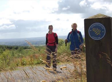
Steeped in local myth and legend, the Sliabh Beagh Way meanders through the valleys of Co Tyrone, the drumlins of Co Monaghan and the lakeland of Co Fermanagh.Start Point:
H669522
Finish Point:
H365342
Route:
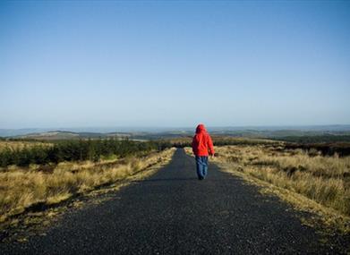
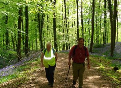
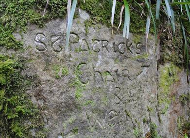
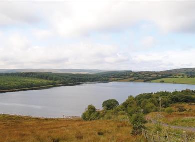
This two-day walking route follows a mixture of country lanes and forest tracks as it explores the varied countryside around south Fermanagh. A remote path across the expanse of moor around Sliabh Beagh is one of the highlights, while good signage and generally firm terrain make it suitable for all fit walkers. Section 1 Aughnacloy to St Patrick's Chair and Well The route begins along a series of country lanes. From the main street in Aughnacloy, begin by heading west along Ravella Road. This soon brings you into pastoral surrounds, with fields on both sides. After 2km, cross the bridge over the River Blackwater. This river marks the international border, and for the first half of the route you will be crossing back and forth between County Fermanagh and County Cavan, in the Republic of Ireland. Around 400m beyond the bridge, turn right onto a smaller lane, then turn left at the next T-junction. This brings you to a large painted church in the hamlet of Cavan. Turn right here, then right again 1.5km later. Before long you arrive at the route's first off-road section. On the left you'll see the wooden gate and turnstile that guards the entrance to Favour Royal Forest. Pass through this and follow a track through immature deciduous trees. A mixture of native saplings were planted here in 2000 as part of the People's Millennium Forests scheme. Follow the track as it swings left, then look out for a footpath that leads off to the right. Follow this across a footbridge, then turn left onto a track on the opposite bank. This brings you to another turnstile at the forest exit. Join a road and turn right, then, 400m later, turn left onto another forest track. Here you pass through mature pine forest. Keep straight ahead at a track junction, then turn left onto a road. Follow this road for 2.5km, climbing beside Altadaven Wood. The section ends at the southern end of the wood, where you'll find a car park for St Patrick's Well and Chair. Did You Know? Ireland was once covered by massive deciduous forests, but these native woodlands were gradually cleared and by 1900, less than 1% of the country was wooded. In 2000, one native tree was planted for every household in the country as part of the People’s Millennium Forests scheme. Favour Royal Forest was one of 16 sites chosen to host the new woodlands. Section 2 St Patrick's Well and Chair to Bragan This section follows country roads as it climbs to a high moorland viewpoint. Unless you're in a rush, it's well worth beginning with a five-minute detour to visit St Patrick's Well and Chair. From the car park, walk along the track to a barrier, then turn right and climb a set of forest steps. The chair is hewn from massive boulders, and is located along the ridge some 100m further on. The moss-cloaked stones make this an evocative place, and it's tempting to linger a while to soak up the atmosphere. When you're ready to leave the forest, continue south along the road. Take the second road on the left, which offers good views over Lough More. You now follow a series of narrow lanes and descend across a river to reach the main R186 road. Each junction is signed to help keep you on the right course. Cross straight over the R186, following signs towards Bragan Penal Cross. The road climbs gradually and is flanked by trees on both sides. After 3km you emerge from the vegetation to a sudden view across open, peat-cloaked hillsides. This is the expanse of moor that surrounds Sliabh Beagh. Continue to the highest point of the road, marked by a picnic area and an open landscape that allows fine views in all directions. You'll also notice a sign directing you left to Bragan Penal Cross. The cross itself is a detour of a few hundred metres from the road, and it commemorates a local priest, Father McKenna, who was shot here around 1754. Did You Know? Tradition relates that St Patrick said mass in the chair in Altadaven Wood, and blessed the nearby well. However it’s likely that the site's importance pre-dates St Patrick. The name Altadaven translates as 'Glen of the Druid, or Devil' and archaeological evidence indicates that the chair was probably also used for pre-Christian rituals. Section 3 Bragan to Muckle Rocks Now follow a moorland path across the lower slopes of Sliabh Beagh. From Bragan, continue along the road for 1km, descending steadily to a T-junction. Turn right here, then turn right again after 1.5km. Follow this lane uphill for 800m. Where the road bends sharply right, continue straight ahead onto a stone track. After 400m, turn left onto a faint path across the open moorland. The turf is springy underfoot as you pass along the right hand side of an old drainage ditch. Cross a stream with the help of a metal footbridge and continue ahead, following marker posts across the peaty ground. At the top of a hummock, the waters of Lough Aportan come into view below. Here the trail veers abruptly to the right, and you head northwest to join the end of a track. Follow the track, swinging left at a junction and continuing towards Lough Antraicer. Shortly before this lough, the waymarkers indicate a right turn and a return to open ground. Pass along the western side of the lough, crossing two more footbridges on the way. Soon you arrive at the end of another track. Follow this for around 600m, then watch out for a signed right turn back onto the moorland. The route runs parallel to Mullaghfad Forest for a while, then makes a sharp left turn. Cross a footbridge over the Coolbrooke River and enter the trees, then turn left onto a forest track. Now follow the signs through three track junctions to reach the road at Muckle Rocks. Did You Know? Just north of the forest at Muckle Rocks lies Shane Barnagh’s Lough, and a nearby outcrop of sandstone is known as Shane Barnagh’s Stables. The name recalls an outlaw who roamed across Northern Ireland in the 17th century. He used the rocks for hiding stolen livestock, and rumours persist of a horde of undiscovered treasure still buried beneath the lough. Section 4 Muckle Rocks to Eshywulligan Country lanes now carry you to Mullaghfad Forest, and an enjoyable stroll past several upland lakes. At Muckle Rocks, turn right onto the road and follow the tarmac for 1.5km. Here you pass Mullaghfad Church, a remote, stone church with an external bell. A number of fine, ancient yew trees can also be seen in the graveyard. Shortly beyond the church you arrive at a T-junction. Turn left here. After another kilometre along the tarmac, the route turns right and you embark along a series of tracks that lead you through Mullaghfad Forest. The first track begins with a steady climb through the pines and brings you to a T-junction. Turn left here, and you'll soon find yourself passing along the shore of Lough Cushkeery. Just a few hundred metres later you reach the larger Jenkin Lough. If it's a warm day, the placid waters of these lakes provide a pleasant place to take a break. Such remote, upland loughs are a haven for wildlife, with fish species such as brown trout, pike, perch and eel living beneath the water, and creatures like frogs, newts and dragonflies thriving on the margins. Continue past the lakes to reach a T-junction with a wider track. Turn left here and follow this track as it swings round to the left and passes beside Lough Nadarra. At the next junction turn right, and descend to meet the road at Eshywulligan. Did You Know? Mullagh fad parish Church dates from 1836, and must be one of the most remote churches in Ireland. It has never had an electricity supply and just a handful of services are said here each year. The cemetary contains the graves of two Special Ulster Constabulary Officers ('B' Specials), who were killed here by the IRA in 1921, during the Anglo-Irish War. Section 5 Eshywulligan to Tully Forest A climb along a moorland road brings you to the traverse of two forestry plantations. Turn right where you join the road in Eshywulligan and follow the tarmac for 1km to a crossroads. Now turn left and climb past Lough Nabull, heading towards the hill of Carnmore. In poor weather, the open peat moorland near here can seem a featureless and desolate place. Shortly before the top of the hill, turn right onto a gravel track signed to Lough Corry. Descend to the shore of the lake, which is popular with fly fishermen seeking to catch brown trout. Follow the track past the western shore of the lake, then sweep left past several signed junctions. Now climb over the brow of a hill in Lisnaskea Forest and descend past Eshcleagh Lough to reach a road. Turn right here and continue for 1.5km to a T-Junction. Turn left here, then take the next right. This brings you to a track that leads into Tully Forest. Keep right at a junction after 250m, then begin to undulate across a series of hummocks. Along with Altadaven Wood, Tully Forest remains a stronghold of the native red squirrel. Though you'll be lucky to catch sight of this elusive animal, look out for nibbled nuts and pinecones along the track that provide evidence of its presence. Where the slopes are free of trees, there are also good views across the surrounding countryside. Now descend steeply to a track junction, where you turn right and meet the barrier that marks your exit from Tully Forest. Did You Know? The hill of Carnmore plays a central role in Irish Mythology. When Noah took to sea in the ark, a second ship also set sail, containing Noah’s son Bith, Queen Cesair and her fifty maids. The ship came to rest in Ireland; Sliabh Beagh is named in Bith’s honour, while his body lies under Carnmore, which was once topped by a massive burial cairn. Section 6 Tully Forest to Lisnaskea A series of country lanes winds gently towards the finish in Lisnaskea. From the exit barrier in Tully Forest, the route continues straight ahead, following the track across an expanse of moor. After a kilometre you reach a concrete farm lane; turn left here, then quickly right onto a country road. Descend through several road junctions - all of which are signed - to arrive at the main B36 road at Ballagh Cross. Cross straight over the B36, continuing ahead along a smaller road. Now take the first turn on the right, soon enjoying the slightly incongruous sight of an old church being used as a farm building. Follow the road as it turns sharply left and descends steeply between the fields. Continue past Kilmacbrack Lough, which is home to a flock of whooper swans during the winter months. These impressive birds make the 1,500km migration to reach this lake from Iceland each year. Just 1km beyond the lake you reach the small village of Donagh. Here the route turns left, then quickly right. You are now on a road that climbs past the church and begins a picturesque journey along a hillside to the northwest. The verges are sometimes lined with trees, but where the vegetation falls back, there are good views west across the myriad islands of Upper Lough Erne. Roughly 4km from Donagh you reach a T-junction. Turn left here, then turn right 500m later. A final descent brings you to the main street in the heart of Lisnaskea, and the official end of the route. Did You Know? The Gaelic name for the village of Donagh is Domhnach, meaning 'Place of Patrician Origin'. This implies a link with the ancient Roman Republic. The name matches the archaeological record, because the remains of an Early Christian church or monastery, dating from around the 7th century, can still seen in the village today.
Distance:
40 miles
Terrain:
Minor roads, track and moorland
Point of interest:
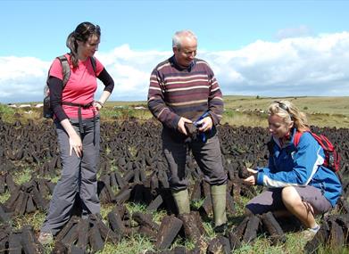
Sliabh Beagh ASSI, St Patrick's Chair, Loughs, peat bogs
Facilities:
Car parks and picnic sites are situated along the route
Publication:
Sliabh Beagh Waymarked Way Guide.
Publication availability:
Contact Killymaddy Tourist information Centre Tel: 028 8776 7259 or alternatively, available to download on this webpage.
Nearest town:
Clougher
OS map:
Sheets 18, 19 & 27
Accessible terrain:
Minor road, off road tracks and moorland
Book Tickets
Facilities
Provider Preferences
- Free (parking charges may apply)


