

Book Tickets Online
About
The Cuilcagh Way is a waymarked route that stretches for 33km through a breath taking patchwork of habitats in southern Fermanagh. The route can be walked in sections and provides stunning views, fascinating geology, mystifying wildlife, captivating archaeology and natural history: enough to whet anyone’s appetite for adventure. The Cuilcagh Way is part of the Marble Arch Caves Global Geopark.Start Point:
H129 356
Finish Point:
H129 356
Route:
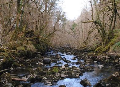
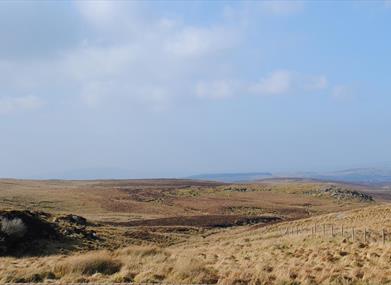
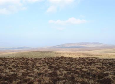
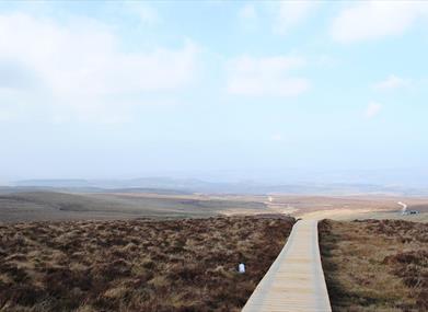
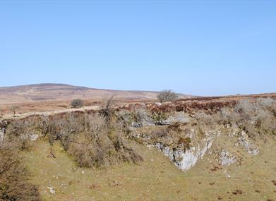
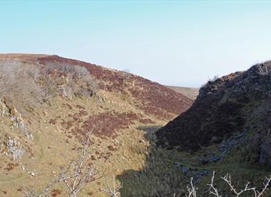
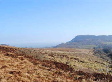
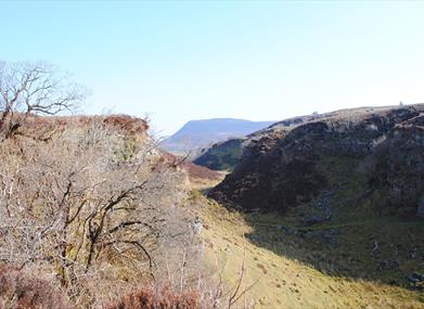
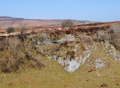
Section 1 Cladagh Glen (Total Distance – 1.6 miles Highest Point – 175m) The Cuilcagh Way begins in the car park at Cladagh Bridge. Cross the stone stile or pass through the wooden gate and follow the wide stone path into Cladagh Glen. Go through the next wooden kissing gate to enter Marble Arch Caves Global Geopark. The path follows the Cladagh River taking you to a series of steep wooden steps to the left of the arch after which the caves are named. At the top of the wooden steps (121 in total) is a concrete path, which leads you through two kissing gates to Marble Arch Caves Visitor Centre. The Way then follows the tarred avenue to Marlbank Loop Road. Go right for 340m along the Loop and then left into Cuilcagh Mountain Park. Section 2 Cuilcagh Legnabrocky Trail (Total Distance - 4.6 miles Highest Point – 666m) *PUBLIC NOTICE* There is temporarily no access to the Cuilcagh Way beyond the end of the boardwalk for conservation reasons. The route will be temporarily closed at the end of the boardwalk to relieve pressure on the sensitive habitat in this area. Marble Arch Caves UNESCO Global Geopark continues to work towards a long term solution with relevant authorities to conserve this fragile habitat while still allowing visitors to appreciate and enjoy this stunning landscape. We ask visitors to keep to the designated path and to turn at the end of the boardwalk. The habitat in this area is fragile and we kindly request that walkers respect the environment and do not stray from the designated route. Your cooperation with this is appreciated. From the Mountain Park car park, the Way leads towards the flat, tabletop summit of Cuilcagh Mountain. The walk takes you up a long stony track that climbs for 4km (2.5 miles) at this point the walk joins the boardwalk. As you ascend, take time to admire the wonderful vistas behind you. On the summit of Cuilcagh Mountain is a Bronze Age cairn dating back to the period 2,500 to 500 BC. This is an excellent vantage point and on a clear day both the Atlantic Ocean and Irish Sea are visible. The vista crosses over counties Tyrone, Donegal, Cavan, Leitrim, Sligo and Roscommon. If the weather is particularly favourable you might even catch a glimpse of the Nephin Beg mountain range in County Mayo. Section 3 Cuilcagh Hiker’s Trail (Total Distance – 5.6 miles Highest Point – 666m) From the summit of Cuilcagh Mountain the descent is steep. The landscape below is a blanket bog studded with stones and clumps of heather. Exposed patches of limestone display their fossil rich make up. A pothole is the term used to describe the entrance to the caves due to their vertical nature. The descent continues and reaches a plateau where the pathway leads out to the Gortlaughany Viewpoint. Section 4 Legacurragh Valley Trail (Total Distance – 4.2 miles Highest Point – 310m) Returning from the Gortalughany Viewpoint along the plateau the Way continues through the valley between Trien (424m) and Benaughlin (370m). The next section crosses relatively dry land and takes you past a cairn and ancient burial site at Myalla, known locally as the Giant’s Grave. The blanket bog which covers the mountain was once used a fuel for Florence Court. The next section crosses relatively dry land and takes you past a cairn and ancient burial site at Myalla, known locally as the Giant’s Grave. From here the Way passes through thick heather before entering the tree cover offered by a forest of Sitka spruce, lodgepole pine and larch. After a short, uneven section, a hard-surfaced lane takes you through Cove Wood to a wider stone lane coming downhill, around a number of sweeping bends to a T-junction. Turning right, you pass Glen Wood Forest Nature Reserve before making a left on to a much narrower path which weaves its way through Florence Court Forest and Cottage Wood, in part alongside and occasionally over a number of small streams. When you come to a number of other paths and tracks follow the Cuilcagh Way signposts to the main tarred avenue leading to Florence Court House. Cross the avenue and follow the path leading to the left taking you to the Forest Service car park. Section 5 Florence Court Forest (Total Distance - 4.5 miles Highest Point – 270m) The initial part of the walk from the Florence Court Visitor Centre car park 1 skirts around the grounds of Florence Court House which enjoys a majestic countryside setting. The charming 18th century mansion offers guided tours and the estate provides good facilities for relaxation and refreshment in the Stables Tearoom before pressing on with your walk. When starting your walk from the car park, follow the Florence Court waymarked red trail, for the next few kilometres it takes you along narrow tracks which twist and turn an undulating course past mixed deciduous woodland crossing the Larganess River in several places, the constant burbling of the river making this section a delight. As you reach the edge of the forest you will pick up the trail sign for the Cuilcagh Way (Florence Court Forest Trail). Things get a little more rugged as you traverse across open farmland edged with dry stone walls. If you are vigilant, you may spot the elusive Irish hare. Larger than rabbits, adult hares have black tips on their ears and their longer back legs give them a distinctive walk or ‘lope’. Gortmaconnell Rock is a prominent feature on the landscape ahead, the trail skirts around the base of the hill to descend to the country road. The last 1.5km stretch of your journey will take you along the Marlbank country road to the Marble Arch Caves Visitor Centre. Please be aware: · It is important to choose a route that suits everybody in your group. You are strongly recommended to walk Cuilcagh Mountain with OSNI or OSNI Discover Series map 1:50,000 Sheet 26 available in most shops and Visitor Information Centres. · Weather conditions on Cuilcagh Mountain can be quick to change & inhospitable all year round making way finding difficult in poor visibility at any time of the year. · Equip yourself for walking in a mountainous area, waterproof clothing, boots, spare clothing, map, compass, first aid, food, drink etc. · Carry a map and stay to the way marked trail. Be aware that mobile reception in the area is poor. Let someone know where you have gone and when you are expected back. · In an Emergency: call 999 or 101 and ask for Mountain Rescue.
Distance:
20.5 miles
Terrain:
Rough mountain terrain
Point of interest:
Florence Court, Cuilcagh Mountain, Marble Arch Caves
Facilities:
Car park available at Florence Court, Cladagh Glen and Marble Arch Caves
Publication:
Cuilcagh Way - A Walker's Guide
Publication availability:
Available from Marble Arch Caves or Fermanagh Visitor Information Centre
Nearest town:
Belcoo
OS map:
26
Book Tickets
Facilities
Provider Preferences
- Free (parking charges may apply)


