Official tourism website for Northern Ireland
En

Tullaghoge Fort

Tullywiggan Road, Tullyhogue, County Tyrone, BT80 8UB
Image of a couple looking over to the fort

Book Tickets Online

About

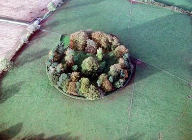
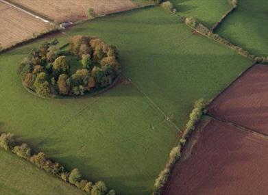
Tullaghoge Fort was a royal power centre which came to historical prominence in the 11th Century when it was a dynastic centre and inaugural place for Cenel nEogain (later the O’Neills). It is a polygonal embanked enclosure, separated from an outer bank by a wide flat space and no outer ditch. From its hilltop position, it commands wide views of the area and is visible for miles around. The site was abandoned by 1622.

No unaccompanied children under the age of 16.

Facilities

Parking & Transport

  • On site parking

Provider Preferences

  • Free (parking charges may apply)

Guide Prices

Ticket TypeTicket Tariff
TicketFree

Free admission

Video

  • Tullaghoge Fort

Map & Directions

Opening Times

* Open Access

What's Nearby

  1. Killymoon Castle

    Killymoon castle sits in picturesque surroundings overlooking the Ballinderry River on…

    1.36 miles away
  2. A family walking through the forest.

    The attractive eighteenth-century demesne is now a forest park. Colourful in spring and…

    4.4 miles away
  3. The front of Lissan House from the garden

    Lissan House is an enchanting country residence set within a 260 acre demesne of ancient…

    5.25 miles away
  4. Wellbrook Beetling Mill

    Wellbrook is nestled in an idyllic wooded valley. As you come over the hill and see the…

    5.57 miles away
  5. Springhill

    Step back to 1912 as you experience the Lenox-Conyngham home on the morning they left to…

    5.87 miles away
  6. Large wooden sculpture of a giant sitting on the ground leaning against a tree holding a big stick.

    Journey through nature and spark your imagination all year round. A diverse 176 hectare…

    7.38 miles away
  7. Man dressed in costume leading a group

    Ranfurly House is an impressive Victorian building located in Dungannon and gateway to…

    7.49 miles away
  8. Aerial view of Dungannon park lake

    Dungannon Park is a seventy acre oasis centred round an idyllic stream fed lake. The…

    8.41 miles away
  9. Image of Castle Caulfield ruins

    Ruins of mansion built by Sir Toby Caulfield in 1619. Gatehouse with murder-holes and…

    8.49 miles away
  10. Image of a white cottage with a thatched rood and green door

    A Fishermans Thatched Cottage, approximately 250 to 300 years old. The nearby Gort Moss…

    8.66 miles away
  11. Three ladies looking up at Ardboe High cross

    A 10th Century Cross situated on a rocky height on the shores of Lough Neagh. It is a…

    8.73 miles away
  12. Peatlands Park

    We invite you to come and explore Peatlands Park. This beautiful area has a wonderful…

    9.84 miles away
  13. The Argory

    The Argory was built in the 1820s and its hilltop location offers wonderful views over…

    10.4 miles away
  14. Image of the Beaghmore stone circle with the sun setting in the distance

    Mysterious complex of 7 Bronze Age stone circles and alignments. It's where megalithic…

    10.68 miles away
  15. A couple looking up at a telescope at the OM Dark Sky Observatory

    Take a journey through time and space with a visitor experience that’s out of this world.…

    10.77 miles away
  16. A woman walking along a path in Davagh Forest.

    The true definition of a hidden gem, Davagh Forest is an International Dark Sky Park and…

    11.03 miles away

Map & Directions

Road Directions

Directions from Town:In Ballymully Glebe townland, 2½ miles (4 km) south-south-east of Cookstown, east of the B162 Cookstown to Stewartstown road. The entrance is on a difficult corner, with a small car-park at the foot of the hill, from which an uphill path leads to the site.

SunMonTueWedThuFriSat
2324252627281234567891011121314151617181920212223242526272829303112345