

Book Tickets Online
About
Taking the walker through a magnificent land of geology, wildlife, history and folklore, this route passes a wealth of rivers, ancient monuments and exposed hill summits before reaching its end in the beautiful Glenariff Forest Park.PUBLIC NOTICE SECTION 2: The Croaghan Way is currently closed as a precaution against wildfire. The private land manager has reluctantly had to take this decision. It is uncertain how long the closure will last but Council will continue to liaise with the landowner to monitor the situation on the ground and provide updates accordingly.
Start Point:
D114406
Finish Point:
D185215
Route:
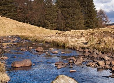
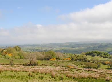
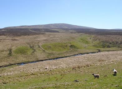
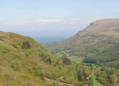
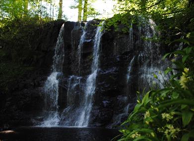
The Moyle Way is a challenging, two-day walk that explores the northern-most Glens of Antrim. Following a mixture of forest tracks and remote upland moor, the route includes a visit to the slopes of Trostan, Antrim’s highest summit at 550m. The mountain sections can be wet and rough underfoot, and full navigation skills are required in bad weather. Section 1 Ballycastle to Breen Bridge The route begins by climbing through a forest on the eastern slopes of Knocklayd Mountain. From The Diamond, start by following a sign that directs the Moyle Way south along Fairhill Street. This road ends after 300m and several tracks continue ahead into Ballycastle Forest. Turn right at the junction and follow a track under an old stone bridge. You are now passing along the line of the old Ballycastle Railway. Continue along flat ground for 600m, then turn left and pass over a stile into the forest. Here you begin to climb gently, following a track between birch trees. Soon the track swings sharp left and the angle of ascent increases. Climb to a junction and turn right, with the surrounding trees now dominated by tall, dark pine. As you near the brow of a hill, the gravel turns to tarmac underfoot. You are now about 210m above sea level, on the eastern slope of Knocklayd. Descend slightly, then turn left at the next junction. Roughly 600m later, turn right onto a narrower track that squeezes through the densely planted trunks. A final left turn at a T-junction brings you to the forest exit. Now join a lane and turn right, heading in the direction signed to Armoy. Follow the road as it undulates around Knocklayd's southeastern slopes, with good views east over Glenshesk. As you progress the trees of Breen Wood also come into sight across the valley - this is your next destination. Descend steadily to a junction with the B15 road at Breen Bridge, which marks the end of the section. Did You Know? Ballycastle Railway was a narrow gauge line that ran linked Ballycastle to the town of Ballymoney. It opened in October 1880, and most services took around an hour to complete the 17 mile journey. Even in the heyday of rail transport it was never a very profitable line, and it closed for good in 1950. Section 2 Breen Bridge to Orra Beg PUBLIC NOTICE: The Croaghan Way is currently closed as a precaution against wildfire. The private land manager has reluctantly had to take this decision. It is uncertain how long the closure will last but Council will continue to liaise with the landowner to monitor the situation on the ground and provide updates accordingly. Climb another forested hillside to reach remote mountain surrounds. At Breen Bridge, cross straight over the B15 and continue along a rough road to the metal gate that marks the entrance to Breen Wood. The lower part of this forest contains a rare fragment of native oak woodland. Follow the track straight ahead as it begins to climb the slopes of Bohilbreaga. Many of the trees have been cleared here, allowing good views back across Glenshesk. Climb steadily through several junctions, all of which are signed. Pass over the top of the hill, and when the track starts to descend, look out for a waymarker on the left. This directs you along a firebreak to the edge of the plantation. Turn right here and descend along a strip of grass just inside the boundary fence. You'll need to duck under the boughs themselves to reach the bottom of the slope. Now climb a stile out of the forest and cross a footbridge over the Glenshesk River. Turn right onto a beautiful section that follows an earthen track upstream alongside the river. Follow the track almost to its end, then veer right and cross a slatted concrete bridge. Now climb over rough ground at the side of Altahullin Gorge. Head left beside a forestry plantation for 200m, then turn right and pass along a firebreak to reach the firmer surface of a forest track. The track leads through the trees for 2km, then brings you to a road. Turn left and follow the road for 1km to reach the Orra Beg parking area. Did You Know? Massive deciduous forests once covered most of Ireland, but true native woodland is now confined to rare pockets. Breen Wood Nature Reserve harbours one such enclave of ancient oak wood. Locals believe this area may have been saved because it was considered fairy land, and inhabitants feared cutting the trees would engage the wrath of the fairies. Section 3 Orra Beg to Glendun Road The 508m-high summit of Slievenorra is the highlight of this section. At Orra Beg parking area, turn right onto a gravel track. The track climbs steadily through the trees for almost 1km, then exits the forest and you find yourself suddenly deposited on a high, open mountainside. The surrounding terrain looks rough and it's easy to be grateful for the firm surface of the track. As you climb, spare a thought for the doomed members of the McQuillan and O’Neill clans, who perished near here with no such firm surface to save them. The track becomes steeper and twists through several switchbacks as you make the final ascent to the summit of Slievenorra. From here there are wide-ranging views over the Antrim hills and the northeast coast, and on a clear day the outline of Scotland is visible on the horizon. Notable landscape features include the solitary cone of Knocklayd to the north, and Trostan to the southeast. Follow the track between the two communication masts that adorn the summit. Around 100m beyond the second mast, look out for a waymarker directing you left onto open ground. Descend southwest along a faint footpath, crossing rough moorland that is wet and rather boggy in places. As you pass a small copse of pine trees, a rough bog track consolidates underfoot. This carries you down to the forest boundary. Continue along a firebreak between the trees and cross a wooden footbridge to reach a gravel track. Turn left here and follow the track for 600m, then turn right. This brings you to the Glendun Road. Turn right and head along the road for almost a kilometre, where the ascent to Trostan begins. Did You Know? The north-eastern slope of Slieveanorra once played a prominent role in local history. During the Battle of Orra in 1559, the MacDonnell clan covered the ground with rushes to make it appear solid. Members of the rival McQuillan and O’Neill clans were tricked and floundered into chest-deep bog, only to be slaughtered as they tried to struggle free. Section 4 Glendun Road to Glen Ballyeamon The route continues across more mountainous terrain on the slopes of Antrim's highest peak. Turn left off the Glendun Road and descend across a footbridge over the Glendun River. The waymarks now direct you east, directly up the rough slopes of Trostan. The path is sometimes faint underfoot, so follow the marker posts carefully. The climb begins gradually but becomes steeper as you near the top, with occasional wet patches to negotiate along the way. At the top of the slope you cross a fence some 500m southwest of the summit. The good news is that from here, it's downhill almost all the way to Waterfoot. The route descends over rough tussock grass on Trostan's south-western shoulder, bringing you to the edge of a forestry plantation. This is the northern-most extremity of Glenariff Forest. Turn right here and follow a line of old fence posts along the top of the trees for 150m. Now turn left along a firebreak. The ground here is wet in places, with several fallen trees to avoid and streams to cross. After about 800m, veer right to join a gravel forest track. Turn left onto the track and descend more easily through the trees to a T-junction. Turn left here and cross an old stone bridge over the Essathohan Burn. Immediately beyond the bridge, turn right and follow the bank of the river downhill, passing the beautiful Essathohan Waterfall on the way. This brings you to the B14 road in Glen Ballyeamon, and the end of the section. Did You Know? Now consigned to relative isolation, Trostan was once part of a thriving mining industry. The mountain's volcanic past has left it rich in red laterite, a soil rich in iron ore. By the late 1800s iron was being mined at several sites around Trostan's slopes, and the mountain even had its own railway line to transport the minerals to port. Section 5 Glen Ballyeamon to Glenariff This forested section brings you past some of the biggest waterfalls in Glenariff Forest Park. From the B14 road in Glen Ballyeamon, continue straight across the tarmac and join the end of a track. After 600m you arrive at a track junction. Turn right here and keep right again at the next junction and soon you'll arrive at the A43 road, immediately opposite the entrance to Glenariff Forest Park. Cross the road and follow the left-hand lane of the access driveway. Climb steadily for roughly 1km to arrive at a large car park. There are great views from here down the cliff-fringed valley of Glenariff, and across the Sea of Moyle to Scotland's Mull of Kintyre. Now follow signs that direct you right, around the car park towards the visitor centre and café. Follow a path that descends past the front of the building to reach a track. Turn left here and begin to reverse the park trail marked by red walking arrows. This leads you on a zigzagging descent down the hillside, past more fine views over the glen and its sheer rock escarpments. Near the bottom of the slope, look out for a left turn onto a smaller path. This brings you to a viewpoint beside the Inver River, beneath the impressive Ess-na-Crub Waterfall, which translates from the Gaelic as 'The Fall of the Hooves'. Continue across a footbridge over the Glenariff River and turn right onto a path on the opposite bank. Now pass around the Laragh Lodge restaurant to reach the end of the section. Did You Know? Irish mythology relates how Glenariff's waterfalls were created by the warrior Oisín. Oisín was being pursued up the glen by Vikings and tried to climb a cliff to safety. A rope suddenly appeared to help him, which he realised was the tail of a huge grey horse. The horse then transformed into a stream and ran over the cliff edge, plunging the Vikings to their deaths. Section 6 Glenariff to Waterfoot Quiet rural lanes and a grassy riverside path now carry you gently to the end of the route. At the Laragh Lodge restaurant, join the end of a road and follow the tarmac uphill. After 400m the road forks; keep right and join a road that runs along the base of Glenariff. Continue past a series of houses and farms, then look out for a small stone bridge after roughly 2.5km. A sign indicates a left turn immediately after the bridge. Cross a stile and start to follow a farm track alongside a field. You'll need to negotiate several more stiles before the track turns into a pleasant grassy path, and you find yourself on the bank of the Glenariff River. Sea trout often swim upstream here, and you might see local fishermen trying their luck along the bank. The next 2km of the route is spent in quiet, wooded surrounds between the flowing water and a line of trees. As you draw closer to Waterfoot, you begin to pass beside the houses on the outskirts of the village. The path eventually turns right and comes to an end on a small, suburban housing estate. Turn left here and follow the road for the final few metres to reach Waterfoot's main street, the official end of the route. Did You Know? The name Glenariff translates from the Gaelic as 'ploughman's glen', probably in reference to the fertility of its soil. It is the biggest of Antrim's nine glens, and often called the 'Queen of the Glens'. Like all its neighbouring valleys, it was shaped by giant glaciers during the last ice age. Please be aware that this walking route passes through areas of open land such as hillside, working farmland and working forests. Livestock may be present, ground conditions may be uneven or wet underfoot and all forestry signage should be adhered to. Please refer to the ‘Walk Safely’ information that can be found at the link below.
Distance:
26 miles
Terrain:
Various off road terrain & roads
Point of interest:
Five of the Glens of Antrim, Glenariff Forest Park, Breen Oakwood National Nature Reserve
Facilities:
Car parks along the route. Refreshments at Ballycastle and Glenariff Forest Park (seasonal).
Publication:
Moyle Waymarked Way Guide
Publication availability:
Ballycastle Tourist Information Centre - tel: 028 2076 2024. Alternatively, available to download on this webpage.
Nearest town:
Ballycastle
OS map:
5 & 9
Accessible terrain:
A mixture of road walking and off road unsurfaced tracks and forest paths.
Book Tickets
Facilities
Provider Preferences
- Free (parking charges may apply)


