

Book Tickets Online
About
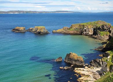
This route, from Portstewart to Ballycastle, passes through the Causeway Coast Area of Outstanding Natural Beauty, a World Heritage Site and several Areas of Special Scientific Interest. It includes views of wide bays, sandy beaches, dramatic cliffs and off-shore rocks.
Please note: Diversion via Glenstaughey Road - This is an interim measure to address the issue of the on road section between Ballintoy and Ballycastle on the Causeway Coast Way, Causeway Coast & Glens Borough Council will continue to work towards an off road coastal path.
Start Point:
C812367
Finish Point:
D114406
Route:
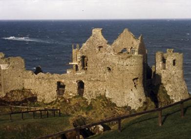
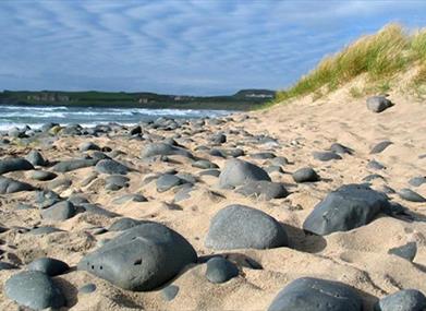
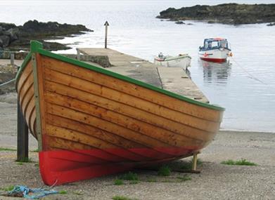
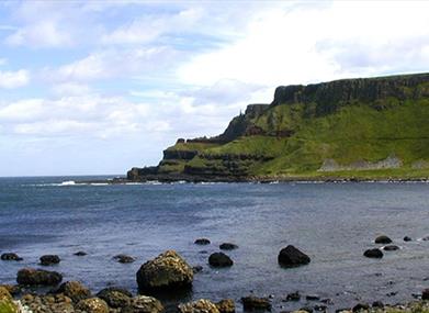
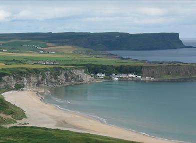
This superb, two-day walking route takes you along Northern Ireland's most celebrated coastline. High cliffs, secluded beaches and numerous historic and natural landmarks are just some of the treats on offer. With frequent access points and terrain suitable for all fit walkers, this is one route you'll remember for years to come. Section 1 Portstewart to Portrush (10km) The route starts with a popular stretch of path that carries you between two Victorian seaside resorts. Begin opposite Portstewart Golf Club. Before you set off, it's well worth making the 20m detour to visit Tubber Patrick, or St Patrick's Well. Then follow the path towards the sea. Turn right onto a wide pavement that passes between the shore and a line of waterfront houses, heading towards the crenellated outline of O'Hara's Castle. The path squeezes past the seaward side of the castle (now a school), climbing onto a balcony built into the cliff. Now descend a flight of steps and continue north along Portstewart promenade. Just beyond the picturesque harbour, look out for a route marker directing you up a flight of steps between two houses. The steps lead onto the cliff-fringed headland of Portstewart Point. Continue along the promenade, then a short stretch along the A2 road leads out of town. At a golf course look out for signs directing you left, along low-lying coastline beside the greens and fairways. There are often different paths to choose from, but just keep as close to the shore as possible. As you near Rinagree Point, the path climbs steeply to a headland with good views in both directions. Continue along the edge of the cliff, occasionally dipping down to cross a cove. Here you pass the promontory that once held Ballyreagh Castle, though little remains of the building today. Another short stretch beside the A2 brings you to a sudden view over Portrush. Follow the path across grassy slopes to reach the promenade, which runs the length of West Strand and brings you to Portrush harbour. Did You Know? The site known today as Tubber Patrick, or St Patrick's Well, was originally used by prehistoric communities as a source of water, as well as being venerated by pagan pilgrims looking for medical cures. Later, when Ireland's patron saint passed through the area around 450 AD, he blessed the spring and it became equally important for Christians. Section 2 Portrush to Portballintrae (9.3km) A long, sweeping beach and a medieval castle are highlights of this section. Continue past Portrush harbour and onto a path that runs around Ramore Head. This is a great viewpoint, with Dunluce Castle clearly visible on the cliff top some 4km to the east. Now follow the path around to Curran Strand, or East Strand as it is known locally. Set out along the beach, following the sand for over 2km to reach the parking area at White Rocks. This area derives its name from the striking limestone cliffs that line the back of the beach.Follow the route markers up to the A2 road and turn left beside the tarmac, towards Dunluce Castle. Although you'll be walking along a pavement beside a busy road for the next 3km, fantastic coastal views keep your progress interesting. After 2km, detour left onto a short access lane to reach Dunluce Castle. Perched spectacularly on a rocky promontory high above the sea, it's well worth pausing on your journey to explore the site properly. A quick exploration of the grounds will reveal the sea cave that completely undercuts the castle, once providing a personal disembarkation point for seafaring visitors. Now return to the A2 road and continue to follow it east. You soon pass a place where the carriageways split, then, 500m later, reach a left turn towards Portballintrae. Follow this road into the heart of the village, passing round the back of the central cove and harbour. Continue to a car park above a larger beach, which is known as Runkerry Beach. Did You Know? Dunluce Castle is one of Ireland's most spectacular medieval castles, perched on a crumbling basalt outcrop above the pounding surf. There has been a castle here since the 13th century, and it was the seat of power for the MacDonnell clan who dominated this part of Ulster during the 16th and 17th centuries. Section 3 Portballintrae to The Giant's Causeway (4.3km) This section is entirely off-road, bringing you round a beach and onto the high, wild coastline that characterises the middle part of the route. From the car park above Runkerry Beach, follow a gravel footpath downhill. Cross a footbridge over the Bush River and turn right onto a wooden boardwalk that traces the bank of the river. At a junction with a gravel path, turn left. You now pass through an extensive sand dune system, walking beside the track of the Giant's Causeway and Bushmills Railway. Cross the tracks twice to reach a wooden gate, where you should turn left. Follow this path towards the beach, then veer right and descend across a footbridge at the end of the sand. Continue between a slipway and the impressive building of Runkerry House, which dates from the early 1860s. The path now climbs onto the cliff tops, passing around the edge of Runkerry Head. This is the start of a beautiful and dramatic stretch of natural coastline that will continue for the next 10km. From the top of the headland, there's a great view east towards the Giant's Causeway. Dip across a cove, then continue to an information sign detailing the walking trails around the causeway. You have just joined the Green Trail, which follows this path back to the visitor centre. Continue around the headland, past the white building of the Causeway Hotel. Just beyond this you reach a flight of steps heading down to your left. It may not be obvious, but you are now on the grass-covered roof of the Giant's Causeway visitor centre. Did You Know? The Giant's Causeway is Ireland's only natural World Heritage site. Some 40,000 hexagonal columns were created here during a period of intense volcanic activity some 60 million years ago. An analogy often used to illustrate the cooling process of the lava is the cracking of lake beds when they dry out in the sun. Section 4 Giant's Causeway to Dunseverick Castle (7.3km) A grassy path continues along the cliff tops and over the route's highest point. From the Giant's Causeway visitor centre you have two options. If you have visited the causeway before, simply continue along the cliff-top path, also signed here as the Red Trail. If you haven't been here before and want to explore the shoreline formations, turn left and descend the flight of steps, following the Blue Trail beside the access road. Explore the main cluster of columns at your leisure, then continue east along a low-level path, past the formation known as The Organ, to reach another set of steps on the right. These are the Shepherd's Steps, and a steep climb to the top will reunite you with the cliff path. The cliff path now continues east along the seaward side of a fence, passing above a series of precipitous coves. The second of these is known as Port na Spaniagh and contains the wreck of the Girona, one of the ships from the ill-fated Spanish Armada. With height established approximately 100m above the ocean, the path undulates past the dramatic rock scenery around Benbane Head. Hamilton's Seat, at the tip of the headland, marks the highest point of the entire route. You now begin a steady descent southeast, passing above Port Moon to reach Dunseverick Castle. Little remains of this ancient promontory fort, which is reputed to have been at the end of one of the five roads emanating from Tara. Later St Patrick was to bless the castle, although it was eventually sacked by Vikings and fell into ruin, being replaced as a local stronghold by Dunluce. Did You Know? The Girona was one of 24 ships from the 1588 Spanish Armada that were wrecked along the Irish coast. Of the estimated 1300 people on board, less than 10 survived. In the 1960s a team of divers investigated the wreck and salvaged the greatest haul of Armada treasure ever recovered, which is now on display in Belfast's Ulster Museum. Section 5 Dunseverick Castle to Ballintoy Harbour (7.8km) To enjoy this section at its best, check the tide times before you set out and avoid walking past White Park Bay at high tide. If the tide is high, you'll have to follow the A2 road all the way from Dunseverick village to Ballintoy. From Dunseverick Castle, continue east along the coastline. After roughly 800m you pass beneath the white houses of Dunseverick village. The coast is lower now, and you pass over a couple of grassy knolls then climb some stone steps to reach a lane. From the laneway continue down to Dunseverick Harbour which has newly upgraded toilets and shower facilities (the shower facilities can be booked by contacting the Causeway Coast & Glens BC). Follow the waymarkers from Dunseverick Harbour towards Gid Point and Portbraddan along the newly upgraded and diverted pathway with stunning views of Bengore Head to the North West and Rathlin Island to the North East. Passing through the natural basalt archway to reach Portbraddan you will pass the remains of a salmon fishery and a row of cottages. Drop onto the rocky shore and turn right towards White Park Bay. Access to the bay is protected by limestone cliffs that rise from a jumble of slippery boulders. At high tide these boulders may be impassable, but if the tide is in your favour then a few minutes of careful boulder hopping will carry you onto the 2km sweep of golden sand. Cross the beach to its eastern end, where the route skirts around the base of more cliffs. Again, this section may be impassable at high tide. Otherwise, it is an easy hop across the rock slabs to reach grassy ground. The coastline now shatters into a series of rock arches, stacks and islets. Follow a footpath, then a track, to reach the car park at Ballintoy harbour. Did You Know? As well as being a favourite location for summer activities, White Park Bay contains an extensive sand dune system that provides a protected habitat for many species of fauna and flora. This was also one of the first places in Ireland to be settled by Neolithic communities, and numerous tools and tombs have been unearthed around the bay. Section 6 Ballintoy Harbour to Ballycastle (12.6km) Visit the thrilling Carrick-a Rede Rope Bridge before following a road to the finish. Leaving Ballintoy may be easier said than done, because this is one of those quiet, picturesque little harbours that compel you to sit down and take it easy for a while. When you're ready, climb away from the water along the twisting access road. At a bend beside the church, turn left onto a footpath. This grassy trail leads across fields to the cliff top, where it curves past Sheep Island. Soon you arrive at the car park for Carrick-a-Rede Rope Bridge. If you want to visit the bridge, pay your dues at the entrance kiosk and continue east along a well-benched path for 1km. Here you can cross the 20m suspension bridge to Carrick-a-Rede Island. The outpost affords particularly good views over Rathlin Island and Scotland's Mull of Kintyre. Retrace your steps back to the car park and turn left. Climb along the access road, passing an old lime kiln to reach the B15. Turn left, taking care because there is no footpath and traffic travels quickly along the road. From here, the route continues on road (B15) for 6km towards Ballycastle. For an optional diversion that travels along the quieter Glenstaughey Road, turn right 500m after leaving the access road from Carrick-a-rede. The Glenstaughey Road rejoins the B15 after 3.2km. After 2.4km, turn left onto Carnduff Park. Pass several houses, and where the road bends left, turn right onto a farm track. This takes you between fields and rejoins the road near a sign marking the boundary of Ballycastle. Continue straight ahead along the road, descending towards the town centre. Pass the harbour and seafront amenity area, then keep straight ahead at a roundabout. Follow Quay Road for 800m to reach the historic square known as The Diamond, the official end of the route. Did You Know? A rope bridge has been raised annually at Carrick-a-Rede for 250 years. The bridge is erected each spring and taken down before the autumn gales, giving salmon fishermen access to their summer nets. The salmon migrate past the island, giving rise to its Gaelic name Carrig-a-Rade, which translates as 'The Rock in the Road'. Please be aware that this walking route passes through areas of open land such as working farmland and tidal zones. Livestock may be present and ground conditions may be uneven or wet underfoot. Please refer to the ‘Walk Safely’ information that can be found at the link below.
Distance:
33 miles
Terrain:
Varied tracks, beach, rock, road
Point of interest:
The Giant's Causeway, Dunluce Castle, Carrick-a-rede (owned and maintained by National Trust).
Facilities:
Car parks along the walk. Refreshments available at most towns and villages along the route and at several of the tourist attractions.
Publication:
Causeway Coast Waymarked Way Guide
Publication availability:
Coleraine Tourist Information Centre, tel: 028 7034 4723. Alternatively, a copy of the Guide is available to download on this webpage.
Nearest town:
Portstewart
OS map:
Sheets 4 and 5
Accessible toilet facilities:
Yes
Accessible terrain:
Varied tracks, beach, rock & road
Book Tickets
Facilities
Provider Preferences
- Free (parking charges may apply)


