Official travel trade website for Northern Ireland
En

Gortmore View Point

Bishop's Road, Limavady, Derry/Londonderry, BT49 0FJ
Person standing beside Manannan Mac Lir statue looking at fields and blue sky.

Book Tickets Online

About

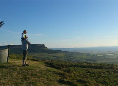
Gortmore is a stunning Viewpoint is situated on the Bishop's Road, on the Binevenagh Loop which is part of the Causeway Coastal Route. On a clear day breathtaking views extend across to Donegal and the islands of Islay and Jura off the west coast of Scotland. Picnic facilities are available.
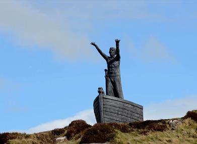
In addition, a sculpture of Manannan Mac Lir, a sea god originating from this area can be viewed from this scenic viewpoint. Off road walks are also available.

To get to Gortmore from Limavady - The Bishop’s Road begins a few miles north east of Limavady town. Take the Windy Hill Road (B201) and turn left onto the Bishop’s Road; Gortmore is approximately 5 miles from this junction.

To get to Gortmore from Castlerock/Downhill – Follow Mussendun Road (A2) signed as Causeway Coastal Route. When you descend into Downhill turn left onto Bishop’s Road as it rises steeply. Look for the brown & white signs for Binevenagh Scenic Loop and Gortmore. Gortmore is approximately 2 ½ miles along this road

Facilities

Attraction Facilities

  • Open Evenings
  • Open Mondays
  • Open Sundays

Catering

  • Picnic Area

Parking & Transport

  • On site parking

Provider Preferences

  • Free (parking charges may apply)

Add Gortmore View Point to your Itinerary

Close window

Call direct on:

Tel+44 (0) 28 7776 0650

Map & Directions

What's Nearby

  1. Benone Strand, multiple recipient of the European Blue Flag and Seaside Award, is a…

    1.33 miles away
  2. Downhill is a golden sandy beach stretching from Downhill Cliffs in the east towards…

    2.52 miles away
  3. Mussenden Temple is located in the beautiful surroundings of Downhill Demesne near…

    2.84 miles away
  1. Hezlett’s picturesque thatched cottage exterior hides a fascinating early timber frame…

    2.84 miles away
  2. Binevenagh is a tranquil area where the sights of Lough Foyle and Donegal can be seen on…

    2.87 miles away
  3. An inscribed stone cross at Duncrun marks the site of St Patrick's Monastery and the…

    2.91 miles away
  4. Castlerock is a 1km (0.7 mile) long stretch of beach between the sea cliffs of Downhill…

    3.83 miles away
  5. A well preserved Martello Tower at Magilligan Point, an important historical site in…

    4.51 miles away
  6. Magilligan Point is the tip of one of the largest sand dune systems in the British Isles.…

    4.51 miles away
  7. Between Portstewart and the mouth of the River Bann lies the golden sands and domineering…

    6.06 miles away
  8. Have you ever wondered how Broighter Gold Rapeseed Oil make their award-winning Liquid…

    6.91 miles away
  9. Opened in 1842, the Limavady Union Workhouse is reported to be one of the best preserved…

    7.46 miles away
  10. Rough Fort, on the Limavady to Ballykelly road, is a remarkable earthwork construction…

    7.76 miles away
  11. Coleraine Town Hall presides over the central shopping piazza in Coleraine. Designed by…

    8.23 miles away
  12. Mountsandel Wood is the earliest known settlement of man in Ireland dating to between…

    8.74 miles away
  13. This scenic and tranquil park on the outskirts of Limavady offers spectacular riverside…

    8.97 miles away
Previous Next

Map & Directions

Back to Top

Tourism Northern Ireland

Don't Miss