Official travel trade website for Northern Ireland
En

Burntollet Wood

Co Londonderry
Burntollet Wood

Book Tickets Online

About

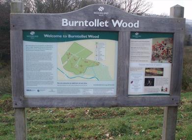
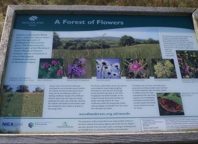
Burntollet Wood sits in the picturesque Faughan Valley, just south-east of the city of Londonderry. The 24-hectare (59-acre) wood, still in its infancy, sits adjacent to Ness Country Park – an Area of Special Scientific Interest containing fragments of rare ancient woodland. The Woodland Trust has planted over 43,000 native trees at Burntollet, mostly oak with scatterings of ash, alder and wild cherry. The young trees will buffer the nearby pockets of ancient woodland, slowly linking habitats together and providing an extended haunt for the Valley’s precious wildlife. In summertime, visitors will be treated to 11 hectares (27 acres) of gloriously coloured wild flowers. Vibrant displays of yellow rattle, birdsfoot trefoil, red campion, and ox-eye daisy await you. The flowers, interspersed with clover, barley and oats, provide a valuable habitat for numerous species of insects and birds.

Start Point:
509 108

Finish Point:
509 108

Route:
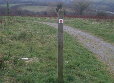
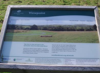
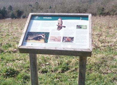
Kissing-gates, wooden seats and several quaint stone bridges have been installed. Have a seat and admire the stunning views over the wider Faughan Valley with its native woodland and rolling farmland. On a clear day, feast your eyes upon County Tyrone’s Sperrin Mountains which rise up to greet you. Schoolchildren have made their mark by designing and creating special mosaic tiles. Each tile was handmade with tiny pieces of coloured pebbles, carefully pieced together to form the image of a woodland creature. Strategically placed, the tiles now form the basis of a much-loved nature trail. Leave Ervey Wood Car Park and follow the red waymarker arrows around Burntollet Wood, in a clockwise direction. You will pass by several viewpoints and information panels describing wildlife and wildflowers that can be found in the area. Pass through a kissing gate to bypass a private property, before re-entering the wood through another kissing gate. Continue to follow the path back to Ervey Wood Car Park.

Distance:
1 miles

Terrain:
Wide, gravel paths

Point of interest:
Viewpoints, wildlife, wildflowers

Facilities:
Facilities available at the nearby Ness Country Park Visitors Centre

Publication:
http://www.woodlandtrust.org.uk/en/about-us/publications/countries/Documents/burntollet.pdf

Publication availability:
http://www.woodlandtrust.org.uk/en/about-us/publications/countries/Documents/burntollet.pdf

Nearest town:
Derry/ Claudy

OS map:
7

Accessible terrain:
no

Accessible signage:
no

Facilities

Provider Preferences

  • Free (parking charges may apply)

Map & Directions

What's Nearby

  1. The Archive and Genealogy Service of Derry City Council has responsibility for the…

    0.1 miles away
  2. Dominating the skyline on all approaches to the city of Derry~Londonderry is Saint…

    0.18 miles away
  3. Derry~Londonderry is the only remaining completely walled city in Ireland and is one of…

    0.21 miles away
  1. The Verbal Arts Centre is an educational charity founded in 1992 and now located in the…

    0.22 miles away
  2. A neo-Gothic church of 1872. built of whinstone with sandstone dressings. Iit is…

    0.28 miles away
  3. The new Siege Museum and Exhibition is a permanent display of the history of the Siege of…

    0.3 miles away
  4. Explore the Blue Coat School Heritage Centre and discover the compelling, and often…

    0.31 miles away
  5. The Tower Museum is home to The Story of Derry exhibition and the Derry Girls Experience.

    0.38 miles away
  6. Fashioned in neo-gothic style, the Guildhall is one of the most striking buildings in the…

    0.4 miles away
  7. Void is a contemporary art gallery that commissions and produces a visual arts programme…

    0.42 miles away
  8. The museum is a public space where the concept of Free Derry can be explored in both…

    0.42 miles away
  9. The Peace Bridge has become an integral part of the city’s infrastructure and is held in…

    0.45 miles away
  10. Ebrington, a former military barracks just across the Peace Bridge, with a rich history,…

    0.54 miles away
  11. Located on the banks of the River Foyle along the south side of Ebrington Square, Mute…

    0.54 miles away
  12. In the steep, wooded Glen of the Burntollet River, south-east of Derry/Londonderry, lies…

    6.25 miles away
  13. Set in the Burntollet Valley within Ness Country Park, this nature reserve provides the…

    6.3 miles away
Previous Next

Map & Directions

Road Directions

Burntollet Wood is approximately 11 km (7 miles) south-east of the city of Londonderry and almost 5 km (3 miles) north-west of Claudy. Travelling along the A6 from Belfast to Londonderry, pass through Dungiven and proceed for approximately 19 km (12 miles). On the right hand side of the Glenshane Road you will see Ness Nurseries. Just after Ness Nurseries, take a right turn to Ervey Wood, as marked by road signs. Follow the signs to Ervey Wood/Ness Country Park car park. For information about public transport, visit www.translink.co.uk or phone 028 9066 6630.

Public Transport Directions

There is a regular bus service between Derry & Dungiven on the A6. From the main road it is a 2.5 mile walk to the visitor centre. For Further Info contact Ulsterbus 028 71 262 261 or www.translink.co.uk

Recently Viewed

  1. Florence Court Forest Park - Blue Trail

    Type

    Walking & Hiking

    A gentle, even gradient walk through native Irish woodland with historical estate features along…

  2. Hillsborough Forest

    Type

    Forest Parks

    Hillsborough Forest is set in the picturesque Georgian village of Royal Hillsborough and sits just…

  3. Scrabo Country Park

    Type

    Country / Royal Park

    This picturesque country park provides a natural and relaxing retreat to visitors. For those who…

  4. Strabane Golf Club

    Type

    Parkland Golf Course

    Set in the foothills of the Sperrin Mountains, this rolling parkland course is intersected by the…

Back to Top

Tourism Northern Ireland

Don't Miss